Getting to Amsterdam Red Light District

Reaching the Red Light District: A quick overview

The Amsterdam Red Light District location sits in the heart of the historic city centre, making it one of the easiest areas to reach on foot or by public transport. De Wallen is less than 1 km from Amsterdam Centraal Station, with most visitors arriving within 10–15 minutes. Walking and trams are the most common options, while bikes and taxis are useful late at night. As the area is pedestrian-heavy, driving is not recommended, especially on weekends and evenings.

Where is the Red Light District located?

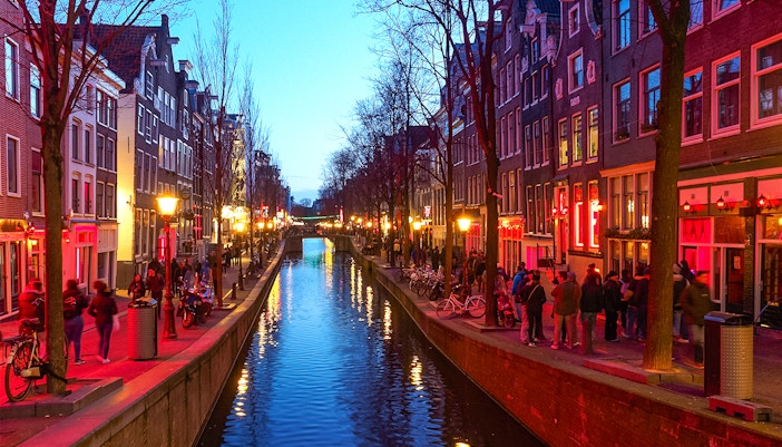
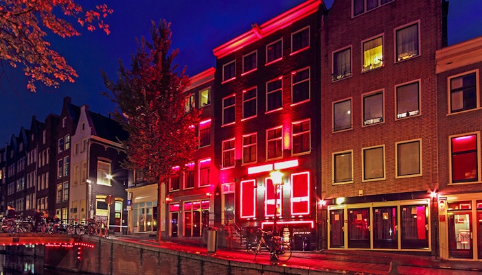
Address: De Wallen, 1012 Amsterdam, Netherlands | Find on Maps

Distance from Amsterdam city centre: Located within the medieval old town, approximately 500–900 m from Dam Square
Time taken from Amsterdam Centraal Station: 10–15 minutes on foot
Access: Open streets and canals; pedestrian access only within core lanes

Amsterdam city centre to Red Light District: Time & distance

From Amsterdam city centre: ~0.8 km

  • Walking: 10–15 min
  • Tram: 5–10 min + short walk
  • Metro: 5 min + walk from station
  • Bike: 5–7 min

Guided tours

Visiting De Wallen independently can be confusing due to narrow alleys, crowd control measures, and local rules around photography and conduct. Guided tours remove the guesswork while adding historical and cultural context.

Why take a guided tour?

  • Clear navigation: Guides handle the most efficient routes through the Red Light District in Amsterdam.
  • Local rules explained: Understand photography bans, respectful behaviour, and current regulations.
  • Historical insight: Learn how Amsterdam brothel locations became regulated and legal.
  • Safety & flow: Avoid congested lanes and peak bottlenecks.
  • Context beyond windows: Explore architecture, canals, and hidden courtyards.

By walking

Walking is the easiest way to reach the Red Light District location from most central neighbourhoods.

Main routes:

  • Amsterdam Centraal Station → Warmoesstraat → Oudezijds Achterburgwal
  • Dam Qquare → Nieuwezijds Kolk → De Wallen

Duration: 10–15 minutes
Cost: Free
Best for: First-time visitors, evening exploration
Cons: Crowded after 8pm

Walking offers the clearest directions to the Red Light District in Amsterdam while letting you orient yourself within the historic core.

By tram

Trams are useful if you are staying outside the immediate city centre.

Lines: 2, 4, 12, 13, 14, 17
Nearest tram stops:

  • Dam
  • Nieuwmarkt
  • Amsterdam Centraal

Duration: 5–10 minutes + walk
Cost: Covered by GVB tickets and day passes
Best for: Visitors arriving from museums or outer districts
Cons: Short final walk through crowded streets

By metro

The metro is efficient if you are arriving from Amsterdam Noord, Zuidoost, or Amstel areas.

  • Closest station: Nieuwmarkt

  • Lines: 51, 53, 54

Duration: 5 minutes from Centraal + 3–5 min walk
Cost: Standard GVB fare
Best for: Longer-distance city travel
Cons: Limited stops near the core lanes

By bike or taxi

Bike:

Duration: 5–7 minutes
Note: Bike parking is restricted near the Red Light District location; use designated racks only

Taxi/rideshare:

Note that drop-off zones are outside De Wallen, so the last 3–5 minutes must be walked. This is not recommended on weekends due to traffic.

Compare your options

ModeDurationCostBest forKey notes

Guided tour

1.5–2 hr

€25–€45

First-timers

Navigation + context

Walking

10–15 min

Free

Central stays

Busiest at night

Tram

5–10 min

€3+

Outer areas

Short final walk

Metro

5 min

€3+

Long distances

Exit at Nieuwmarkt

Bike

5–7 min

Rental

Locals

Limited parking

Getting around in the Red Light District

  • The Red Light District location is compact and best explored on foot. Streets are narrow, busy, and pedestrian-focused. Walking is the only practical way to move between canals and alleys. 
  • Bikes must be parked outside core lanes, and cars are not permitted. 
  • Signage is subtle, so using a map or guided tour helps you understand the layout of the Red Light District of Amsterdam without getting lost.

Things to do in the Red Light District

Red Light Secrets Museum entrance in Amsterdam's Red Light District at night.
Oude Kerk in Amsterdam with canal and bridge in foreground.
Oudezijds Voorburgwal canal with boats and historic buildings in Amsterdam.
Partygoers enjoying a limbo game during an Amsterdam Red Light District pub crawl.
Luxurious red velvet seating area with a pole at Tour de BonTon strip club.
1/5

Red Light Secrets Museum

Explore the history of prostitution in Amsterdam from inside a former brothel.

Book tickets

Oude Kerk

The city’s oldest building, sitting at the heart of the De Wallen location.

Canal walks

Evening strolls along Oudezijds Achterburgwal.

Bars and cafés

Historic pubs mixed with modern cocktail bars.

Discover bars in Amsterdam

Guided brothel tour

Learn about modern regulations and daily life from insiders.

Suggested itinerary for the Red Light District

Evening

Arrive via walking or tram from Amsterdam city centre to the Red Light District around sunset. Start with a guided walking tour to understand the layout and rules.

Night

Visit the Red Light Secrets Museum, then enjoy canal-side bars or a pub crawl experience.

Optional add-on

End the evening with an Amsterdam canal cruise for a quieter perspective of the city.

Handy tips

  • Best time: Arrive before 7pm to explore comfortably before peak crowds.
  • Booking hack: Guided tours sell out on weekends; reserve in advance.
  • Local rule: Photography of windows is strictly prohibited.
  • Navigation tip: Pin the De Wallen location and routes on your map app before arrival.
  • Seasonal note: Summer evenings are the busiest, especially on Friday and Saturday.

Frequently asked questions about getting to the Red Light District

Is the Red Light District inside the city centre or outside it?

The Red Light District location in Amsterdam is fully inside the historic city centre, within the canal ring and medieval core.

Is the Red Light District close to Amsterdam Central Station?

Yes. The Amsterdam Red Light District location is less than 1 km from Amsterdam Central Station. Most visitors reach De Wallen in 10–15 minutes on foot via Warmoesstraat or the canals.

What’s the cheapest way to get to the Red Light District?

Walking from the city centre is free and the fastest for most visitors.

What’s the fastest way?

Walking from Amsterdam Centraal Station takes about 10 minutes.

Is a guided tour worth it?

Yes, especially for first-time visitors who want context, safety, and clear directions to De Wallen.

Do I need public transport tickets in advance?

No, but a GVB day pass is convenient if you are combining multiple trips.

Which metro exit is best for reaching De Wallen?

Exit at Nieuwmarkt station and follow the signs toward Oudezijds Achterburgwal. This is the most direct route to the Red Light District location in Amsterdam without crossing the busiest central streets.

Can I drive to the Red Light District?

No. Cars are restricted, and parking is expensive and far from the Red Light District location in Amsterdam.

What is the easiest landmark to navigate to the Red Light District?

The easiest landmark is Oude Kerk, which sits inside De Wallen. Navigating toward Oude Kerk leads you directly into the core Red Light District location.

Can I reach the Red Light District from Dam Square on foot?

Yes. Dam Square is about 500 meters from the Red Light District location. Walking takes 5–10 minutes and is one of the simplest directions to the Red Light District in Amsterdam.

Are there multiple Red Light Districts in Amsterdam?

Amsterdam has one main Red Light District location in the city centre, known as De Wallen. Smaller window areas exist elsewhere, but visitors usually mean De Wallen when searching for the Red Light Districts of Amsterdam.

Where do taxis drop you off for the Red Light District?

Taxis and rideshares usually drop passengers near Nieuwmarkt, Dam Square, or Centraal Station, as vehicles cannot enter De Wallen. From there, it is a short walk to the Red Light District location.

Is the Red Light District easy to find at night?

Yes. The De Wallen location is well-lit and clearly marked by canals and main streets. Crowds and visible signage make directions to De Wallen straightforward even after dark.

How far is the Red Light District from popular hotels in the city centre?

Most central hotels are within 5–15 minutes of the Red Light District location. Areas like Damrak, Nieuwmarkt, and Rembrandtplein all offer easy access on foot or by tram.

Can I use Google Maps for directions to De Wallen?

Yes. Searching for the De Wallen location or Red Light District location in Amsterdam on Google Maps provides accurate walking and public transport directions.

Are there signs pointing to the Red Light District?

Official signage is limited to managing crowds, but major streets, landmarks, and map apps make finding the Red Light District location in Amsterdam straightforward.

Is the Red Light District close to Amsterdam’s canal cruise docks?

Yes. Several central canal cruise departure points are within a 5–10 minute walk of the Red Light District, especially near Damrak and Centraal Station.

More Reads

Amsterdam Red Light District buildings illuminated at night along a canal.

Best Time to Visit

St. Pauli red light district neon signs during guided tour in Hamburg, Germany.

About the Red Light District

Tour group walking through Amsterdam's Red Light District.

Plan Your Visit